Covered 500 miles today with BIW. Smooth driving through Arkansas and Tennessee along Interstate 40. Enjoyed the blue skies, the redbuds in bloom, the green plants, and the rocks.
Ruthie drove and steered BIW expertly across the Mississippi River. Good by to the West.
Tonight we're camped at Edgar Evins State Park, about an hour east of Nashville. A unique campground with sites cantilevered over the hillside with a view of the lake and marina. Hope the Tennessee engineers allowed for an 18,000 pound load.
Follow the travels of Morey & Ruthie in their Winnebago SUNSTAR, Blowin-in-the-Wind {and other side trips}.
This Fall we're heading back out west. COVID will be in our thoughts as we plan for adventures while we stay safe! Our plans are to head first to Colorado, then zip over to Utah. Lots of hiking and biking are planned along our route.
Friday, March 25, 2016
Thursday, March 24, 2016
Following Georgia O'Keeffe....
photo compliments of Crystal Bridges |
The museum collection includes paintings from some of our favorite artists: Frederick Church, Alfred Bierstadt, George Caitlin, and photographs from Edward Curtis....and then paintings from Georgia O'Keeffe! All of these and many more are displayed at the exquisitely designed Crystal Bridges museum. Even though Bentonville had been off limits; not anymore. (Bentonville was 70 miles off our planned route home, but this detour was worth it!)
As we walked the galleries, we were very impressed with the collection. Starting with early American painters in the 18th century, you continue through the galleries to modern day art and photographs. We did locate the two O'Keeffe paintings. One was purchased at an auction for $44 million (to keep it on display in the United States).
Thanks to the Walton family.
Wednesday, March 23, 2016
The second largest canyon in America......
Palo Duro Canyon, just south of Amarillo, Texas IS the second largest canyon.......really! Stretching over 160 miles, and over 600 feet deep, this canyon has many of the rock formations and colors that we saw at Georgia O'Keeffe's beloved Abiquiu. And then we discovered that Ms. O'Keeffe spend the first few years of her teaching and painting career here in Palo Duro (before moving on to New Mexico). She must have known.....
After driving BIW down a 10% grade road built by the CCC in the 1930's, we reached the floor of the canyon. Unlike the Grand Canyon [the largest canyon in America], our perspective was looking up to the canyon walls and rock formations. This Texas state park encompasses only the northern 20 miles of the canyon. The rest is owned privately and used for ranching and grazing.
Setting up our motorhome at Hackberry campground, we noted all of the turkeys camped out behind our site. Over a dozen turkeys gobbling, wandering for camper crumbs, and strutting their stuff. A nice campground too, with a lot of very friendly campers from all over the States & Canada.
Our next day, we set out on an 8+ mile hike. Without much elevation to climb, we enjoyed the walk through the canyon floor and along the walls. After walking the one mile trail to the trailhead, we set out on the Lighthouse Trail, noted for the Lighthouse rock formation which stands 600 feet from the canyon floor. Then we returned on the Givens, Spicer, Lowry Trail along the canyon rim. More really great colors and rock formations.
Palo Duro Canyon State Park is definitely a place to return to. We need to tell all of our camper friends not to miss this second largest canyon in America.
Friday, March 18, 2016
O'Keeffe Country
We woke up this morning in the heart of O'Keeffe country. Camped at Echo Amphitheater campground in the Carson National Forest, a well situated but also historically special place. (More on this later.)
Georgia O'Keeffe came to this part of New Mexico, Abiquiu, for the special scenery, the incredible light, the blue-blue skies, and the solitude. She rebuilt an adobe house for her winter quarters, and used Ghost Ranch for her summers. We took the tour of her home yesterday; left with the furnishings and artwork as she had left them when she found it necessary to move down to Santa Fe for her few final years. To walk through her home and gardens, and see the views from the many windows, gave us a special understanding of this wonderful artist.
We then drove to Plaza Blanco (White Place), which O'Keeffe used for much of her art. The cliffs and rock colors, the shadows, the light.....in all of the places around Abiquiu are very special. Today we take the tour of more of her favorite places to paint.
Now for the story of Echo Amphitheater: In 1861 a band of Navajos attacked some northern New Mexico settlers and spilled some of their blood over the top of this amphitheater. In 1864 during the forced march when Kit Carson removed over 14,000 Navajos from their lands, they traveled by this same formation. General Carson chose the ten best warriors of the Navajos, murdered them, and spilled their blood down these same walls. Last night, did we hear the echoes of the anguished cries of both the settlers and the Navajos?
Wednesday, March 16, 2016
Tent Rocks [aka Kasha-Katuwe]
A half hour drive south of Santa Fe, is the strangest rock formations, the Tent Rocks (no campsites, not for RVs nor for tents!). Formed from volcanic ash which has solidified and then eroded, the trail through these rocks is amazing.
We hiked the trail which first winds through a slot canyon into a strange world of pine trees and rocks. Then we climbed 600 feet through the tent rocks to the top of the mesa. A stellar view.
Sunday, March 13, 2016
Bandolier National Monument
With the weather staying wonderfully sunny and warm, we decided to check out some more Native American cliff dwellings and pueblos. Bandolier, which was one of the first National Monuments (1916) has maintained these historical ruins.
Our good friends, Steven and Joan, joined us camping here. Together we set out on some great hiking trails and into the ruins. Ladder climbing seems to be the activity of choice on these trails, and so we did the climbing to some alcoves and former native homes. We also checked out the Bradbury Museum in Los Alamos, where the development of the atomic bomb and its impact on our world is on display. Camping at Bandolier, just down the road, we didn't see the glow of Los Alamos....mmmm?
Friday, March 11, 2016
A stop in Albuquerque, New Mexico
Looks like we are finally heading East on our way home. When driving along I-40, a few days in Albuquerque are required. After taking a walking tour of the city and discovering that there are NO historical buildings (built out of adobe, the Rio Grande has dissolved them). In addition to our tour of "old" town, we spent time at the Art Museum; very enjoyable.
For the night, we camped at Coronado County Park. What a place, with a view out our front windshield of the Rio Grande River! (And if the river floods, our motorhome won't melt like the old town buildings.)
On a recommendation, we checked out the Balloon Museum. Albuquerque is the town of the world's largest hot air balloon festival, held every year in October. We learned all there is to learn about the history and the current record setting balloon adventures. On display were a number of these including the first crossing of the Atlantic by balloon. Pretty HOT !!
Thursday, March 10, 2016
El Morro National Monument
Visited by Teddy Roosevelt and designated as one of the first National Monuments by him, El Morro NM was established to "save" the many Spaniard and pioneer inscriptions carved into the soft Navaho sandstone. With a pool of water, precious in this part of New Mexico, many of the travelers took the time to stop and note their passing through this area. Starting with the Spaniards in 1620, through the pioneers passing through on their way to the west coast in the mid 1800s, and then to the tourist's graffiti in the 1930s.
And above "Inscription Rock", is a large pueblo that has been partly excavated. Sitting on top of the mesa, it has a commanding view of the valley on all sides. The pool of fresh water also drew these earlier people to stay and call this area their home.
Tuesday, March 8, 2016
Here in Navaho Country
After driving across tribal lands in some awesome but also desolate territory, we arrived at Chinle, AZ and camped at the Cottonwood Campground at Canyon de Chelly. We spent the next day exploring the canyon and the ancient buildings and culture. Starting at the Visitor Center, we planned our travels to take both the north and south rim roads.
At the many lookouts we walked out to the edge and peered down to the amazing cliff dwelling remains that all became abandoned by the 1350s. Unlike other canyons, Canyon de Chelly has a flat open area suitable for farming at its base. The perennial flow of the river made this a good place to raise crops, and still have the security of living up high in the canyon wall.
Today the Navaho's still farm in the canyon, growing corn, and grazing sheep and their horses.
At the White House cliff dwelling, we took the one accessible trail down 1.25 miles to the canyon floor and the ruins. This was one of our favorite trails as it went through two short caves, along slick rock ledges, before crossing a bridge with the Navaho horses grazing nearby.
For the second day in Navaho country, we headed to Gallup, NM which is the Navaho Nation's center. On the way we stopped at the Hubbel Trading Post. Still in use today, this store was established in the 1880's trading food and dry goods to the Navaho for their agricultural products and crafts. Absolutely beautiful Navaho rugs, baskets, pottery, and carvings are for sale; but now trading for dollars.
Sunday, March 6, 2016
Goodbye to the Grand Canyon
We have never had three posts on one of our RV adventures, but here is the exception.
On our last day, we packed up our RV and headed out the eastern entrance with our last stop at Desert View. Brought back good memories of when we camped here four years ago.
This time we revisited Mary Colter's watch tower, which was built to replicate the many watch towers of the native Americans in the southwest. The interior was painted in the 30's by the grandson of Cloud Mountain who was performing native music when we were visiting. Cloud Mountain then took us up the winding staircase to explain the murals.
Wonderful music and a fascinating story of how the first human (predecessor of the Hopi) traveled down the Colorado River through the Grand Canyon. He traveled in a carved out log, and met his bride (of the snake people) at the Gulf of California where the river ended its journey. They traveled back home together with a bag of special items, but he couldn't wait to open the bag as instructed, and the promised wealth reverted back. Note the circle divided into quadrants with the story beginning on the top left and goes clockwise.
Saturday, March 5, 2016
Around and under the rim
Five days here at the Grand Canyon was not time enough. After our day of biking, we did a six mile rim walk, because we just couldn't get enough of the awesome views. We kept wanting to head down into the canyon and explore. With the weather being ideal for this early March visit, walking the rim trail was the perfect choice for the day.
The next day, we selected the Hermit's Trail, which was built in the early 1900s for the Fred Harvey Company to avoid the toll on the Bright Angel Trail. When completed it was advertised as the best engineered trail in the Canyon, where the hiker could stroll down to the specially constructed campground, a couple of thousand feet below the rim.
We found the Hermit Trail to be steeper than our prior hikes below the rim. What once was a trail of man made pavers in the steepest sections, now unmaintained, has become a rocky trail, where we had to watch our footing. Still the two miles down and back made for a great hike. We found different views of the Canyon, and the remnants of this highly engineered trail.
We're leaving the Grand Canyon, but we will back. Maybe a raft trip on the Colorado River; maybe a backpack trip from the North to the South Rim? This is just too incredible a place not to return.
Wednesday, March 2, 2016
The Canyon is Calling .....
Having spent over 3 weeks in arid Arizona; Sedona and the fabulous red rock formations, the Saguaros with their arms and nubs, the great hikes to surprising springs and tanks, and the temperatures hitting 90 degrees.....It was now time to head to pine trees and cooler temps. And, our plans to go to Chiracahua National Monument (one of our favorite parks) were besmirched when we received a message that the roads to the hiking trails were closed .
So what did we do?? The Grand Canyon was calling us... "Come Visit, the temps are perfect, and the views are sublime." So we changed our plans and bee lined; well actually moseyed to the Canyon.
First stop after spending a night at a National Forest campground with pine trees; (no cactus)
was Tonto Natural Bridge State Park. Found this gem of a park on our AAA map. Here is the largest travertine arch in the world!
After a 14% grade to get down to the bridge, and passing the flowering trees, we hiked to the Bridge.
WOW !
BIW had no problem climbing the 14% to continue our journey....Remember, the Canyon is Calling.......So no delays allowed.
Now to the Grand Canyon. Spent the first two nights at the Trailer Ranch campground with full hookups....so we could watch the Super Tuesday primaries, and prepare for our upcoming dry camping. Our first stop when we arrived at the National Park was the Visitor Center and then a walk to the Rim. The Canyon is as awe inspiring as ever!
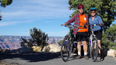
Our first full day, we mounted our bikes and headed to Hermits Rest. Did this four years ago, and it was even better than remembered. One great view after another. After the 20 mile ride, including some 6% grades, we are tired but exhilarated. More Canyon to come before we move on.
So what did we do?? The Grand Canyon was calling us... "Come Visit, the temps are perfect, and the views are sublime." So we changed our plans and bee lined; well actually moseyed to the Canyon.
First stop after spending a night at a National Forest campground with pine trees; (no cactus)
was Tonto Natural Bridge State Park. Found this gem of a park on our AAA map. Here is the largest travertine arch in the world!
After a 14% grade to get down to the bridge, and passing the flowering trees, we hiked to the Bridge.
WOW !
BIW had no problem climbing the 14% to continue our journey....Remember, the Canyon is Calling.......So no delays allowed.
Now to the Grand Canyon. Spent the first two nights at the Trailer Ranch campground with full hookups....so we could watch the Super Tuesday primaries, and prepare for our upcoming dry camping. Our first stop when we arrived at the National Park was the Visitor Center and then a walk to the Rim. The Canyon is as awe inspiring as ever!
Subscribe to:
Posts (Atom)