
Saturday, October 28, 2017
BIW takes a time out in Las Vegas
Wednesday, October 25, 2017
A day with the Fremont Indians

As we arrived at Utah's Fremont Indian State Park & Museum......there was a problem. Didn't just happen, actually happened around 1986 when the engineers who designed I-70, decided to use 2/3s of Five Finger Ridge for raising the highway bed. It turns out that Five Finger Ridge was the location of the Fremont's settlement. All bad news, except at least many of the artifacts including pottery, hunting tools, and baskets were "discovered", and saved for inclusion in the future museum. We would hope that today, such a horrible decision would not be made.
The museum had very i
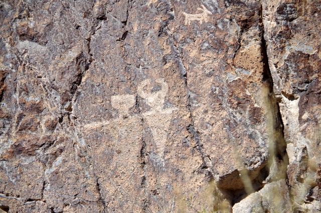 nteresting artifacts and was surrounded by rock cliffs with petroglyphs from 400 AD all the way to the mid 1800s.
 For the night we pulled into the local National Forest campground and discovered a very nice Castle Rock campground. We'll need to remember this next time, for a convenient stop over.

Monday, October 23, 2017
Arches, Arches, and more Arches


First a drive down the Colorado River Canyon to the trailhead for Bowtie and Corona Arch. A hike to both was well worth the effort.


Next day, we drove to the trailhea
 d for Fisher Towers, and took one of our top ten hikes.
 Then there was a "Cowboy" dinner at Red Cliffs Lodge.
Nice of Ruthie to invite me!


Also a day at Arches NP, to hike and see many of the arches. And of course, a must hike was to Delicate Arch. So famous its even on the Utah license plates.
Even a drive up into the Manti La Sal mountains. Took our small Ford Focus on a very unimproved gravel road to a very quaint campground and picnic area on a small lake. A picnic lunch before heading back down to Moab.
And finally, a day of biking along the paved bike trails by the Colorado and up to the National Park.
Thursday, October 19, 2017
Needles section of Canyonlands National Park


This time we pulled in with our motorhome at our chosen site, which although long enough for our RV, had a huge drainage dip..........no way we could get into our site, and the campground was full. Luckily, we stopped in at the Visitor Center, and luck had it that they had an "administrative" site, so we were good to camp!
We stayed for 3 days, but should plan a week next time, as there are so many wonderful hikes through canyons, across slick rock, across scrub plains. The Needles rock formations are so beautiful, and the hikes (though sometimes a little challenging) are just plain, the best. Where else can you be climbing through rubble, walk along a narrow ledge, climb down a ladder at the edge of the abyss, and walk between canyon walls?


Monday, October 16, 2017
Finally, we toured Natural Bridges National Monument!

Although we were disappointed that we couldn't squeeze into their campground (maximum length 26ft with large boulders keeping out the bigger RVs), we did drive the 8 mile loop road.
But how could we just drive the scenic loop? So we parked at a trailhead and hiked to two of the three famous bridges. And what is the difference between Arches and Bridges? Bridges have/had a river flow under them.

 After hiking over 5 miles, we saw two Natural Bridges, up close and personal. We followed the trail to the Sipapu Bridge after walking across the mesa and then down to the wash. The Sipapu is the second largest bridge in the world. Continuing on our hike, we then hiked through the wash to Kachina Bridge, and finally back up to the top of the canyon where our RV was waiting for us. A fairly strenuous hike; but well worth it. Now tired, we continued driving on the loop road, and we have to admit, we only viewed the third bridge, the Owachoma Bridge from the parking lot viewpoint.


And where did we camp for the night? A recommendation from a park ranger: 3 miles outside the park there is an abandoned runway on BLM land. So another boondock.
Saturday, October 14, 2017
Capitol Reef National Park
 he heart of the Waterpocket Fold, there is an oasis in this desert canyon country. Mormon pioneers settled this area in the late 1800s, irrigating their fields and orchards from the always flowing Fremont River. Today the orchards are maintained by the park service, and there are wonderful hikes through the canyons.
There is a 71 site campground set in a former orchard, and still adjacent to apple and pear trees. With no reservations accepted, we understand why the park service now advices to arrive by 10am to get a campsite. So after boondocking our first night, we arrived by 8am and secured a site surrounded by Fall-golden trees. Immediately, we headed over to the Gifford Farm house where we picked up a cinnamon bun, an apple pie, and a strawberry rhubarb pie (all 6"). Over the next few days, we also entered the apple orchard and picked apples...nothing better than fresh picked!


 y we biked the park road to the Grand Wash trailhead. Parked our bikes and headed out the wash through the Narrows. Tall canyon walls closed in to 16 feet, as we walked the wash.


Thursday, October 12, 2017
Boondocking..................
It's about time.
Being such good planners, making reservations where we suspect full campgrounds, were we ever going to boondock? Well, it happened.
 We arrived at Capitol Reef at around 3pm, only to discover that the campground was full (no reservations accepted). Suggested by the campground host, we headed just outside the Park, to a BLM dispersed area. We pulled in and secured some property. Before the sun set, we weren't alone!
Being such good planners, making reservations where we suspect full campgrounds, were we ever going to boondock? Well, it happened.

Wednesday, October 11, 2017
A week at Zion National Park

 e, we realized that this is a very, very special place. Pulled BIW into one of the recently remodeled campsites; paved, level, and lots of space for our screen house, and chairs.
Joining us were our RV friends, Gail & Dan, and my sister, Kathy, and her husband Mel.

 k boundaries we took the East Mesa Trail to Observation Point. After a little over three miles of hiking, we found ourselves overlooking the Virgin River valley at Observation Point. And without the 2,500 foot climb!
Another day we headed toward Angels Landing (this time with a 2,000 foot climb); up Walter wiggles to the West Rim Trail. If we had only brought our overnight backpacks...so magnificent, we wished we could continue this hike for another 14 miles.


Tomorrow we drive out early along Route 12; a chance to rest our muscles.

Tuesday, October 3, 2017
The Havasu Canyon Trail

Here is how we did it................
Morey after a number of phone calls, finally got Lodge reservations for two nights in Supai (the only village by the falls). Included, although we weren't sure, was also the permits to be allowed to hike the trail on Havasupai land. Supai can only be reached by the trail that we hiked. No vehicles.

 e our RVs for a few days while we hiked into the canyon. (65 miles to the Hilltop trailhead.) While at this Cavern RV Park, we checked out the kitschy "Radiator Springs"props. (as in the Disney Cars movie), and all the old stuff..............memories from our childhood. Was this old tourist spot near Peach Springs the inspiration for the movie?
At 6:30 the next morning, we drove to the trailhead and then after checking in,we started the 8 mile
hike down into the canyon to the village of Supai. A steep trail with a drop of o
 ver 1,000 feet in the first mile, it fortunately leveled out and took us down a wash and between towering canyon walls at a less precarious drop.
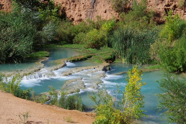
Arriving at the village of Supai, with a small grocery store, a "restaurant" with few choices, and the Lodge, we caught some glimpses of the Havasu Creek and its incredible blue turquoise waters. We were glad that we booked the Lodge for a couple of nights after the arduous descent.

 |
Navajo Falls
|
First was Navajo Falls.....
Then Havasu Falls, with the pools at the base where we should? have gone swimming. The travertine walls on both sides of the falls added to this spectacular place.
 |
| Havasu Falls |
Then to Mooney Falls where there is a long ladder that gets you down to its base. After talking to a number of braver and younger campers, we deferred on the long rickety ladder route, but did climb on the rocks and gaze down at the roaring water.
 |
Morey crossing the creek to one of the campsites.
|
 |
Mooney Falls
|


We did spot the mule train carrying the Gatorade down to Supai.
For the readers: We discovered that there is a helicopter that will transport you to and from Supai (for the less hardy), and there are also mules (we saw too may of them galloping through our hike) that will carry backpacks and supplies. So maybe next time, we will stay at the campground between the blue turquoise waters and have the mules carry our packs?
Subscribe to:
Posts (Atom)